
Update 5/5/24 11:32 AM: The boundaries for Tuesday and Wednesday have changed slightly but are still covering the same general area (just slightly more south). I never intended to do forecasting on this page, I just got riled up by the weather nerds on Twitter.
May has historically always been a month for crazy weather across the U.S. and this May will be no exception. According to the latest A.I. models, if you were to ask yourself when East Central Illinois will begin experiencing it’s fair share of severe weather and potential tornadoes, A.I would likely respond:

As interested as I am to see how accurate these models are for myself (and so far, they’ve been eerily accurate), my out-in-the-elements-and-not-hail-insured vehicle and I are preparing for the worst. So what are we looking at for the next week? Keep in mind, this model is subject to change as the predicted timing for this event approaches.
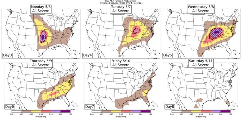
Working our way out from the middle of the concerning area:
Black Dot: They haven’t yet, but I could see forecasters considering this the black dot of doom. Just kidding, it seems to just indicate the center of the area with the most predicted activity.
Hatched/Slashed Area: While I am struggling to confirm this, a hatched area on a typical severe weather forecast signifies a 10% chance that hail will form and fall anywhere within a 25 mile radius of any given point in that hatched area. From my eye, it looks like that will extend from southern Champaign County down to just south of Effingham.
Light Purple: This indicates a 45-60% chance of severe weather in that area. This doesn’t necessarily mean tornadoes per se, as storms producing tornadoes is pretty rare (don’t tell that to the 2024 tornado season).
Coral: 30-45% chance of severe weather. Again, not necessarily tornadoes.
Yellow: 15-30% chance of severe weather
Brown: 5-15% chance of severe weather
All of that was for Tuesday of this week, now let’s get a closer look at Wednesday:

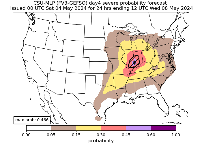
WHEWEEE! This pattern is thanks in large part to a giant bowling-ball trough of cool air that will be moving into Canada and taking it’s sweet time moseyin’ across the country until it dissipates. It causes disturbances in the atmosphere that lead to peaks and dips in barometric pressure, lending further instability to an already charged atmosphere.
We have the addition of a dark purple area on Wednesday’s forecast, indicating a 60-100% chance of severe weather with a hatched area over it so, it’s very likely that

Before anyone starts thinking that I’m nuts for trusting the AI models, here’s an example of their accuracy on 4/30/2024:
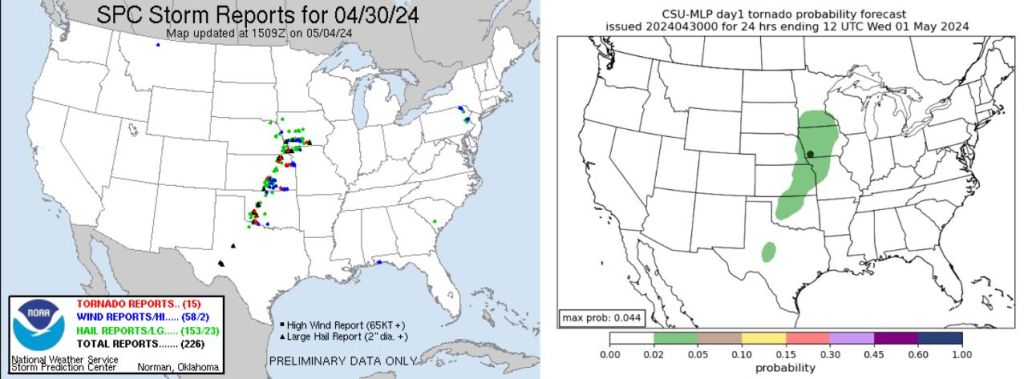
The model on the left shows the actual reported storms and tornadoes on 4/30/24, with the red triangles on the map being confirmed tornadoes. The model on the right was Colorado State University’s AI prediction for where tornadoes would occur on 4/30/24. This was just a random day that I picked, but comparisons from other days show similar accuracy.
With all that being said, if you live in the areas that are predicted to see severe weather this upcoming week, as Ryan Hall Y’all would say: “Don’t be scared, be prepared!” Make sure you and your family have a plan in place should a tornado touch down near you, have extra batteries for your flashlights and weather radios, extra propane for your lanterns (if you’re old-school like me), and remain weather-aware.

Leave a comment