

This map from https://tornadopaths.engin.umich.edu/ shows confirmed tornadoes from an outbreak on 5/7/2024
It has been a long time since I have woken up before the sun, slicked with sweat and in a dead panic. When it happened yesterday, I dismissed it as anxiety over finals but felt pulled toward my back yard and compelled to look at the sky. I knew we had the potential for bad weather, particularly in the morning hours, and the clouds seemed to be issuing a gentle warning. I instinctively grabbed my DSLR before slipping my socked feet into the Crocs by my backdoor. Upon second thought, I removed the socks before stepping outside.
I could feel the morning dew on the grass penetrating the aerating holes in my clogs and knew I had made the right choice in removing my socks. Nobody wants wet socks. I looked up to see quickly moving dark clouds, and pointed my camera upward to try to catch a moment that could potentially become significant (it likely won’t, as the local news station’s meteorologists ignored the shortened video I put on Twitter and tagged them in). Here it is anyway:
It soon began to rain, then pour, then thunder, then… nothing. This monsterous, hail-throwing, tornado-producing squall line kept on moving and losing momentum. I thought my anxiety would dissolve as the clouds did into a clear blue sky. It didn’t. I consider myself to be someone who has impeccable intuition, and I knew something big and scary was coming. I just didn’t realize it wasn’t going to be coming for me.
In the early afternoon, I prepared to make the 1+ hour drive to my college to present my last final project for the semester. It was for my Python (coding) class, and I had turned in the project a few days prior so it didn’t make much sense to me that I would have such a knot in my stomach about it. I’m not one who is shy about having all eyes on me during a presentation, and I trusted that my work was solid. An alert came through on my phone for a tornado watch that included my part of the state, including the town where my college is located. I hemmed and hawed about whether or not I should make the trip, even going so far as to email my professor to ask if my grade would be affected by not attending the class (he didn’t see the email until class had already started), but ultimately determined that I should be able to travel safely. It was just a watch afterall, and I had textbooks to return and a mileage form to get signed.
I arrived to class early (as always) and immediately began watching Max Velocity on livestream. There was some activity happening in parts of Indiana that was concerning to me, as a tornado had been spotted in Terre Haute, Indiana and was headed right for my favorite tattoo shop in Brazil. I became a bit concerned but knew that Indiana was no stranger to tornadoes and it would likely die out before it could reach Brazil. Class began and I closed YouTube to focus on the task at hand. I was picked first to present my project and was back in my seat in no time (I got 100% on the project, by the way). That’s when my bestest best friend of the last 20 years texted me from Coldwater, Michigan to inform me that the sirens were going off in her town and to ask what was going on.

I opened YouTube again and clicked on the first live stream I saw, which was Ryan Hall, Y’all‘s coverage of the storms. He was talking about a large tornado forming outside of Portage, MI and heading toward Kalamazoo but my eyes were trained on the hook echo forming outside of Three Rivers and barrelling it’s way toward my BFF. Thankfully, I’ve seen enough radar images at this point to know that it would likely veer just north of Coldwater, so I encouraged her to stay sheltered just in case but assured her that she was going to be just fine. The storm coming up from Northern Indiana had other plans, but thankfully nothing came of that one for her.
With this outbreak came Michigan’s first ever Tornado Emergency alert. This alert is only issued when there is imminent, life-threatening danger to humans and structures alike. The Tornado Emergency was issued for Union City and Sherwood but was canceled shortly after, as the tornado died almost immediately after the emergency alert was issued.
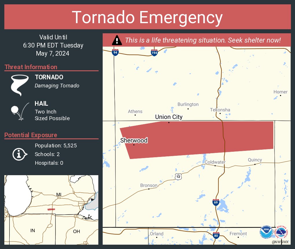
A tweet from @NWSTornado displays the area impacted by the Tornado Emergency alert
This Tornado Emergency is not to be confused with the State of Emergency that has since been called by Michigan Governer Gretchen Whitmer. The State of Emergency cooresponds with a very large, destructive tornado that swept from Portage to Kalamazoo, leaving several dead and many trapped in the basement of a collapsed FedEx facility. To make things worse, Portage suffered a second tornado shortly after the first as emergency crews were working to secure the area.
Thankfully, there were no deaths or serious injuries reported as a result of this storm. There were early reports of a mass-casualty, but that seems to have been directed at property and not people.
With the potential for more harrowing storms this evening (5/8/24), it is important to remain weather-aware. Make sure you have your tornado action plan in place and pay attention to the forecast. I would encourage anyone reading this to check out the two YouTubers I have linked in this article (Max Velocity and Ryan Hall, Y’all) for the latest weather information. They do live streams if the tornado probablility is over 10% in any given area and can sometimes warn of newly developed tornadoes faster than the National Weather Service can issue alerts.

Leave a comment